The Battlefield Of
Alischanz
|
W |
olfram’s supposed source, the Bataille d’Aliscans, contains – apart from the title – absolutely
nothing of any use in trying to locate Wolfram’s battle scene Alischanz.
Wolfram’s description, on the other hand, leaves no doubt
that it is located near
The decisive reference to
this locality is the mention of the sarcophagi lying on that part of the
battlefield on which in certain phases the second battle raged.
Wolfram’s
reference to these sarcophagi has been unjustly devalued by Wolfram researchers
by saying that Wolfram would have known of the legend of the miraculous
sarcophagi in Alischanz by the accounts of a traveller or by the Kaiser-Chronik (Imperial Chronicle of
Charlemagne). In this decisive geographical detail, it is however not the
legend that matters according to which on the morning after the first battle
all fallen Christians were found buried in stone coffins, but the quite
concrete geographical indication that such sarcophagi were scattered on
Alischanz and the fact that in his description of the second battle Wolfram
mentions these coffins every time that in various phases of the battle, the
fighters stormed over this field scattered with these stone coffins.
The
battlefield of Alischanz has several sections, which are characterized by
Wolfram as mountain, slope, wet meadow,
lowland, moor, woods, sarcophagi, source, marsh, salt lake, Larkant, ford and
sea. All the names of these landscape components are definitions for
specific geographical localities. The section of the landscape that Wolfram
depicts with the sarcophagi is only part of the greater battlefield. It is that
part that has lent the whole battlefield its name and that even today can be
defined by the metre, because through excavations archaeologists have
established the exact size of this ancient necropolis.
Whoever
prepares to reconstruct the battlefield of Alischanz with the aid of Wolfram’s
exact references, is well advised to begin with this clearly defined cemetery.
Today, the sarcophagi are no longer to be found where they were placed two
thousand years ago by the Romans and later by the Christians, and where they
were seen by
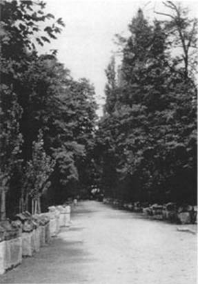
Plate 9. Les
Alyschamps in
The most beautiful specimens are now in the
From
here one arrives at a fairly large plain, it is called: the Elysian Fields,
Aliscamps according to the Provençal dialect. They are situated on the eastern
part of the town
This description illustrates how well Wolfram is informed
about this area, when in his battle report – in which his main concern are not
the coffins, but characterizing the terrain – he depicts the precise course of
the battle. As such, he does not forget to mention the coffins that are lying
about, for example (Wh. 386:2):
nu was Matusaleses kint, Now
Matusales’ child,
der mine gerende
Josweiz, love-seeking
Josweiz,
zorse komn. des puneiz rode forth. His massed attack
was
von maneger storje starc. was
many a contingent strong
beidiu
heide und sarc and
both heathland and coffins
wart
getrett al gelîche. were
trampled down.
Or (Wh. 394:20):
ob der
getoufte sarke Could
it be that the baptized men’s coffins
nu mit starken
huofslegn are
trampled now
iht wol
getretet werden megn? beneath
harsh hooves?
Or (Wh. 437:20):
al über die
sarcsteine, Over
all the stone coffins
dâ die
gehêrten lâgen, where
lay the exalted dead
die ze himele
rouwe pflâgen, who
were at peace in heaven,
mit sweten an
den furt gement with
swords to the ford
wart manc
esklîr, der ungewent was
driven many an eskelir
was daz er
fliehen solte. who
was not accustomed to fleeing.
It must be recognized that with these concise words –
simply according to his precise knowledge of the site – Wolfram says that the
described phase of the battle takes place at a cemetery. He did not want to
boast about the fact that his knowledge went beyond the source drawn from the Kaiser-Chronik
(Carolingian Imperial Chronicle). Wolfram speaks as an objective reporter
who knows that the Esklirs, unaccustomed as they were to fleeing, did just that
towards the ford, passing the cemetery at this special spot (Plate 10).
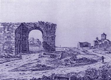
Plate 10.
Cemetery at Les Alyscamps in
Mentioning the coffins was of no greater or lesser
importance to him than mentioning the ford across the Larkant, or referring to
the battle-calls Ipern and Arras yelled out by the Flemish in full
pursuit of the infidels. He describes in all objectivity a certain phase of the
battle with the reserve of a true battle correspondent, fully conscious of the
fact, as he himself states, that his work can only be taken seriously by
avoiding all fantasy.
In
connection with the last quotation (Wh. 437:20), it will now be shown how,
starting from this passage, a topography of the battlefield can be drawn up.
The infidels are fleeing. They are moving in the direction of their ships, i.e.
southwards. Below the cemetery, at the ford, they cross the Larkant. Riding on
in the same direction, they would soon reach the sea, for behind the stream the
sea was, after all, visible from
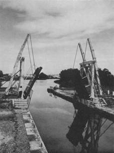
Plate 11.
Drawbridge over Wolfram’s Larkant
On the other side of this waterway we reach the plain Plan du Bourg, behind which we come
across the main arm of the
Whoever halfway recognizes Wolfram’s resolve
to be exact, says to himself: Wolfram could be right. Terramer’s fleet sailed
up the Rhone and is now anchored keel to keel with the front line at the
outskirts of the town Arles on the left bank of the Rhone: from keel to keel, a
line stretching three miles long. A small rowboat serving as gangplank is tied
from each keel to the shore. This formation corresponds absolutely to the way
ships are moored in a river port. The fleet could not anchor this way at sea. Everything
falls into place, down to the assertion that the seashore is here. But knowing
how accurately Wolfram uses his words, one cannot be satisfied with this
assumption yet. One scrutinizes the hydrology of the
Whether this is exactly right can of course
only be established by examining the actual geological circumstances. For the
time being, the rule of thumb of the average yearly deposit may suffice in
order to arrive at the assumption that Wolfram’s reference could in principle
be right: Terramer anchored in the mouth of the
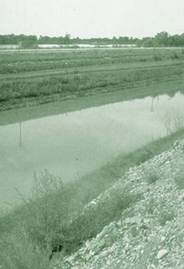
Plate 12. The
Knowing that
When we learn that between the
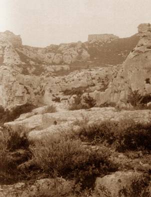
Plate 13.
Mountainous Area with
On the other side
of the Alpillen, towards Pîtit Punt,
there was only a small land bridge – between the morass of Montmajour and the
then still wide open Etang de Maugio or Etang du Comte corresponding to the
present Marais desséchés des Baux – allowing access via land to the “Town of
Morasses” as Arles was called then. This land bridge, which during rainy
periods stood completely underwater and which only after long dry periods,
above all in the autumn, swelled up to a width of some 2 km. was situated in the
region of Barbegal where also the Roman aqueduct ran into the Costa Basse hill (Plate 14).
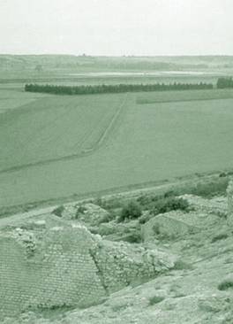
Plate 14.
Roman Aqueduct
At the side of the Costa Basse plateau
From this
observation post on the mountaintop, one kilometre east of Saint-Victor,
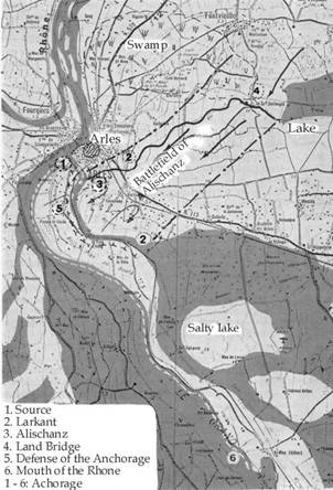
Map of the
Battlefield of Alischanz
To the south lies the dried-up Etang de Meyranne, which
at the time extended as far as the foothills of the approaching
With the Larkant as an example, it will be
shown how exact Wolfram’s concepts match the actual conditions by comparing
them with the geographical reality then and there. Next to the greater and
smaller
During the time of the battle of Alischanz,
the exit of the
If one does not know that this is a loose
gravel area, one translates Wolfram’s concept steinwende (stone wall) with Felswände
(rock walls). There are, however, no rocks in this region, but washed up walls
of
Wolfram describes
der
marcrâve zôch zehant The
margrave went
gein’
dem wazzer larkant
towards the river Larkant
das
ors an sîner hende leading the horse by the hand
bî
maneger steinwende past
many a stone wall
unz
in des wazzers ahganc. and
into the riverbed.
einen
kurzen wec niht ze lanc A
short way, not long at all
reit er durch das
stûdach he
rode through the underbrush
unz er vor im ligen sach until he caught
sight
des weren Vivîanses schilt. of
noble Vivian’s shield.
Wolfram’s geographical expertise, as opposed to the
ignorance of the Bataille d’Aliscans,
is so evident that after inspecting the battlefield of Alischanz, all attempts
to prove that these Chansons de geste
are Wolfram’s source are simply not convincing. In addition, the assumption
made in the chapter Oransch is
strengthened in Alischanz: Wolfram must have known the battlefield personally.
If I may
make another personal remark: locating the sites that Wolfram speaks about
without a guide who knows the sites is, even with our modern means of
transportation, an extremely time-consuming affair. Pitit Punt for example, I only found after several stays over many
years in the region in question, even though Wolfram’s description is so exact
that when looking at the locality, one has the impression that this point would
have to be located straight away.
Without
wanting to detract from Wolfram’s ‘resourcefulness’ in any way, I am convinced
that Wolfram must have been led there by Hermann of Thuringia, and that the latter
must apparently have had a thorough knowledge of the battlefield. One even gets
the distinct impression that Hermann played the role of chief of staff for
Wolfram. In this sense, Wolfram – before finishing his excellent battle report
– would have used a method still applied by an army commander today in planning
an exercise for his troops: Accompanied by his chief of staff, he examines the
terrain beforehand to see if the manoeuvre, which was planned with the aid of
an accurate map, can take place on it as planned.
This
report places the reader so concretely in the midst of the battle that
But
neither does Terramer prove himself a bungler in Wolfram’s battle report. He
orders Pojdius to charge on the flanks, causing
Wolfram
von Eschenbach has taken his battle report very seriously. He knows he has to
describe phases which appear fantastic, but which are nevertheless real. He
stands still by the fact that others lose all measure in their poetic license,
thereby causing the exact descriptions of those committed to relating the
simple historical truth to turn pale. This conscious attitude on the part of a
responsible historian prompts him to make the following remark (Wh. 384:23-30):
ich hoer von Witegen dicke sagn I often hear it claimed about
Witege
daz er eins tages habe durch slagn that on one single day he smashed
ahtzehn tûnst, als einen swamp, eighteen thousand helmets as
if they were
helme. der als manec lamp mushrooms. If you
brought him
gebunden für in trüege, as many lambs
already tied
ob er eins tages erslüege, and he slaughtered
them in one day,
sô wær sîn strît harte snel, he would have to work
fast,
ob halt beschoren ir vel. even if the lambs
were shorn.
Man sol dem strîte toun sîn reht:
dâ von diu mære werdent sleht. that way stories get properly
told.
Concerning Wolfram’s art of limitation in describing the
bare facts or about his gift for immersing himself into the reality of the
fighting, nothing is to be found in the so-called source. This entertainment
genre presents the battle as a great chaos of incoherent single events.
Everything appears haphazard and confused; equally unreal are the descriptions
of the characters. Terramer lacks the most elementary qualities of leadership.
The commander of an army, who is dependent on reliable information, even when
it may be disconcerting, will soon receive no reconnaissance anymore, were he
to treat his scouts in such an incredibly stupid manner as Terramer from the
“source” does with respect to the scout from Cler. This army leader gets
irritated about the only man with initiative he has, because the latter
personally decides to take over the reconnaissance work that he himself failed
to do. He saddles him up with his discontent about the bad news. A capable army
leader, on the contrary, would praise a man for doing something that he himself
failed to do. This is precisely what Wolfram’s Terramer does. He attempts to
extract all the possible results of reconnaissance from his scout, proving
thereby that he is
Even these
small details show the great difference in quality between the two battle
descriptions, which cannot be explained by Wolfram’s character, but only by his
superior detailed knowledge. Since Wolfram himself was a brave knight and a
great poet, but hardly as excellent an army leader, it may be assumed that he
must have visited the battlefield accompanied by Hermann of Thuringia, a proven
army leader.
In any
case, the battle report from Thuringia is qualitatively so far superior to the
one from Aliscans that a military
expert cannot for a moment have the impression that Wolfram’s assumed source is
Wolfram‘s source. On the contrary, were not the fact known that Aliscans appeared earlier, we would have
to agree with the conclusion of every military commander that it is Wolfram who delivers the original
report, while the Aliscans can only be a layman’s tale, devoid of any tactical
understanding of the outstanding original. Purely militarily speaking – this
must be admitted – the roles have simply been reversed. The source lies in
Were a
philologist to agree with this assessment, it would mean that in the future he
would no longer have to verify what Wolfram makes out of his source, what he
adds, improves or leaves out. He would rather have to examine what important
details are missing in the French original battle report and what meaningless
trivialities have been added to the expertly streamlined battle report of the
essential aspects that has been preserved for us in
It has
been said that Wolfram copied from Aliscans,
but that he also ennobled it. The priority in time of Aliscans forbids one from saying the other way around that the poet
of Aliscans copied Wolfram’s
The
objection has been levelled with regard to Wolfram’s Parzival that the only reason for him mentioning the older source
in the person of Kyot is that his copy work from Chrétien will then not be
noticed. But if this were so, he would indeed be a more naïve forger than the
present-day plagiarizers, who also copy upon finding something, but then take
pains to avoid mentioning the author whom they copy by name, not admitting that
they know him.
I do not
mention this to still further cloud the Kyot problem. But attention must be
drawn here to the fact that Wolfram does not criticize the author of Aliscans, but Chrétien de Troyes again.
In
Christjâns
ein alten tymît Chrétien
dressed him
im
hât ze Munlêûn angelegt; in old dimity at Munleun;
dâ
mit er sîne tumpheit regt, anyone
who talks as foolishly as that
swer
spricht sô nâch wâne. shows
his stupidity.
Today we tend to shake our heads at this, since we are so
sure that Chrétien copied William the
Conqueror, Erec and Cligès, but not William of Oransch. Yet, Wolfram must also have known a
The
example of the armour shows the degree of accuracy that Wolfram’s report
reckons with. He says that Chrétien dresses
If Wolfram
was so concerned with levelling criticism, he could have found and criticized
much greater differences in Aliscans.
Those describing him as a “smart aleck”, would have to establish consequently
that he does not seem know his source Aliscans
at all, for then he, the born polemicist, would not have let the chance go by
to criticize others to a much greater degree. With his remark, Wolfram shows
that he believes Chrétien to have written a
This
opinion by Wolfram cannot be refuted. It is certainly possible that an older
version of the tradition exists from which both authors drew independently from
each other. The third party adapting such an original would then be – next to
Wolfram and Chrétien – the poet who wrote Aliscans.
Through his single remark about Chrétien, Wolfram confirms that the version by
Chrétien de Troyes of this unknown French
Wolfram is
no moaner. As a writer of history, he points to a fault. Such faults do not
seem to appear as much in
That
Wolfram is much better informed becomes apparent upon examining his
geographical references. It is therefore, at least theoretically, possible that
he is better informed than we are in other aspects as well. Scientific
statements to the contrary have not been made until now.
If we do
not a priori discard Wolfram’s opinion that Chrétien authored a
We would
like to merely touch upon this theme here. We want in due course to return to
this question of source and summarize the issue here by saying that the
original battle report that Wolfram left us is unique in the entire literature
of war. We are convinced that, next to the geographical expert Wolfram von
Eschenbach, there is just as good a war correspondent Wolfram von Eschenbach.
The question as to whether on top of that he is also a useful historian shall
be examined in the next chapter.
***